 ____________________________

 ____________________________
Newly released emergency map shows residential neighborhoods and Wakeham Elementary School inside projected damage zones surrounding the GKN Aerospace hazmat crisis.
May 23, 2026
By Brian Hews
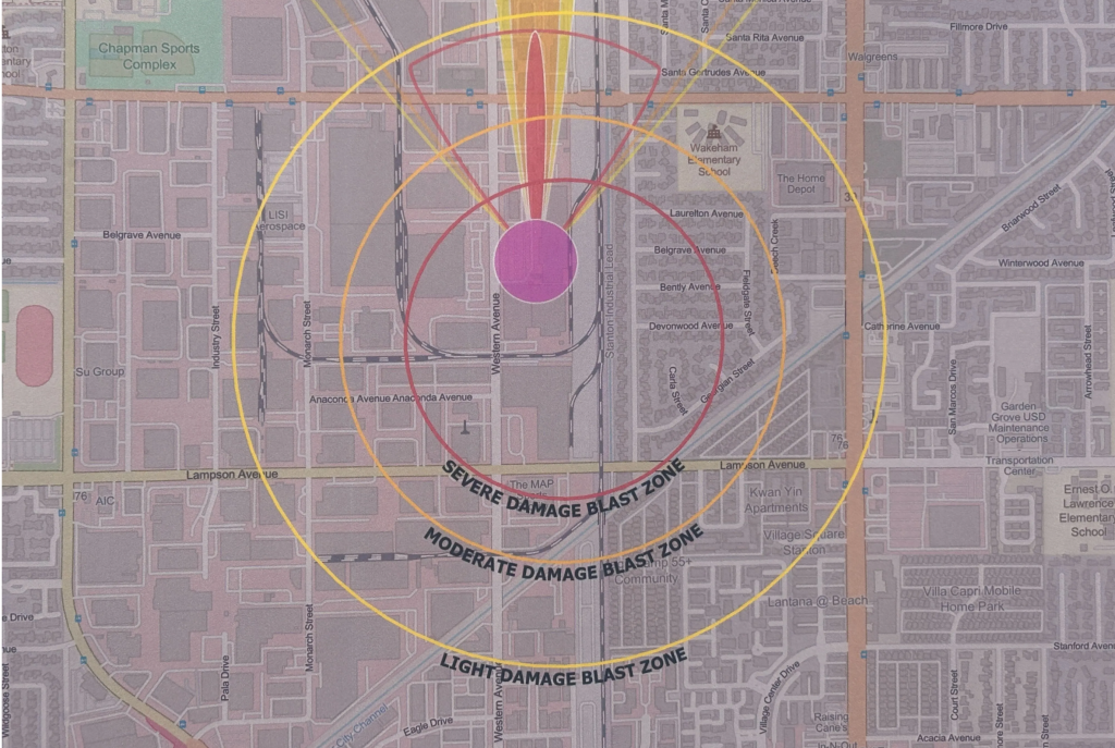
A newly released Orange County Fire Authority operations map shows residential neighborhoods, apartment complexes and portions of an elementary school campus sitting inside projected blast and damage zones surrounding the ongoing chemical emergency at GKN Aerospace in Garden Grove.
The map outlines severe, moderate and light damage zones centered around the aerospace facility near Western Avenue between Chapman Avenue and Lampson Avenue, where officials continue battling a volatile chemical tank containing methyl methacrylate.
Streets appearing inside or directly bordering the projected severe damage blast zone include Belgrave Avenue, Bently Avenue, Devonwood Avenue, Laurelhurst Avenue and portions of Anaconda Avenue near the Stanton Industrial Lead corridor east of Western Avenue.
The moderate and light damage zones extend outward toward Santa Gertrudes Avenue, Chapman Avenue, Lampson Avenue and neighborhoods west of Beach Boulevard, including portions of Georgia Street, Feldgate Street and Santa Rosalia Street.
Wakeham Elementary School appears inside the projected moderate damage area east of the facility.
The map also highlights how closely dense suburban housing sits beside the industrial aerospace corridor, where large quantities of industrial chemicals are stored and used in manufacturing operations.
Officials say the tank could either rupture and spill thousands of gallons of chemicals or potentially explode if crews cannot stabilize temperatures inside the compromised tank.
Mandatory evacuations affecting approximately 40,000 residents remain in effect while fire crews, hazmat teams and chemical experts continue working to prevent what officials have described as a potentially catastrophic event.

Subscribe to get the latest posts sent to your email.