 ____________________________

 ____________________________
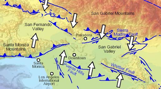
EARTHQUAKE THREAT – Southeast Los Angeles County faces a serious risk from the Puente Hills Thrust Fault that runs directly under the area as seen in this illustration from NASA. Owners of older buildings should have their earthquake risks evaluated to protect their investments and tenants, according to Optimum Seismic, Inc.
By Ali Sahabi, Co-Founder, Optimum Seismic, Inc.
People in Southeast Los Angeles County have more to fear from the nearby Puente Hills earthquake fault than the more notorious, but distant, San Andreas fault.
Experts indicate the Puente Hills fault could kill more people and cause more damage in the Los Angeles area than the more-distant San Andreas because it lies creeping underneath skyscrapers, heavily traveled bridges and freeways, old industrial buildings, and neighborhoods with vulnerable multifamily housing. Its location gives it the ability to produce heavy shaking likely to be felt over a large area, roughly 25 by 15 miles.
Able to cause “the costliest disaster in U.S. history,” according to a study by the University of Southern, the Puente Hills fault could cause the deaths of as many as 18,000 people, 735,000 to lose their homes, and up to 100,000 tons of debris to be generated. Total economic loss could run as high as $252 billion.
The United States Geological Survey presented similar projections, noting that Puente Hills’ destructive power is five times that of the San Andreas. A 7.5 magnitude quake on the nearby Puente Hills fault would cause the same destruction as an 8.0 on the more distant San Andreas although an 8.0 would release 16 times the energy of a 7.5.
The Giant Awakes?
The Puente Hills fault, first discovered in 1999, runs about 25 miles through the Los Angeles Basin, from downtown L.A., through southeast Los Angeles County creating a cross-stitch pattern under cities such as South Gate, Downey, Norwalk, and surrounding communities extending into Orange and San Bernardino counties.
The 6.0 magnitude Whittier Narrows earthquake in October 1987 was what led to its discovery. This was followed by quakes in Chino Hills (2008), Pico Rivera (2010), and La Habra (2014).
A team of scientists from Harvard, USC, and the University of California Los Angeles produced a report in 2017 showing accelerating slip rates along this fault.
“This increase in rate implies that the magnitudes and/or the frequency of earthquakes on this fault segment have increased over time,” the report concluded. “This challenges the characteristic earthquake model and presents an evolving and potentially increasing seismic hazard to metropolitan Los Angeles.
Thrust Quake Dangers
Puente Hills is a thrust quake, which tends to rupture with one side of the fault pushing up and over the bottom side. It shares this quality with other nearby faults that sparked the Sylmar, Whittier Narrows and Northridge earthquakes.
Thrust earthquakes create an accumulated strain that bends the earth’s crust in spots, where the fault has locked up. Seismologists believe that these areas are the spots most prone to future earthquakes.
The force behind these quakes reflects the incredible amount of energy needed to move two tectonic plates toward each other at a rate of about one inch every three years.
It may sound easy to locate these trouble spots, but the reality is that many of these high-pressure areas are located deep underground and cannot be seen or detected – until they burst. Seismologists call these “blind thrust faults.”
Liquefaction
These faults also present an added danger because they are located along the Los Angeles Basin, where local soil conditions are prone to liquefaction – a phenomenon that causes the earth to move like Jell-O when shaken.
When it occurs beneath vulnerable buildings and other structures, the results can be catastrophic.
This is what happened during the 1994 Northridge earthquake on Balboa Boulevard in Granada Hills, where a gas main was ruptured by lateral spreading and caught fire, the Los Angeles Times reported.
Liquefaction also contributed to the devastation of the 1989 Loma Prieta earthquake – when soil and debris used to fill in a lagoon to build the Marina District subsided, fractured and caused horizontal sliding of the ground surface.
The Atlantic magazine, in 2019, describes the effects of liquefaction as horrifying: “Videos of its occurrence look like found-footage documentaries of the Second Coming. Buildings seem to simply slip away, the earth gives out, and the once-steady structures slide into the morass.”
Monster quakes are inevitable in California, but they don’t have to be disasters. It’s important to be prepared in advance to mitigate their impacts.
Older commercial, industrial and multifamily buildings in southeast Los Angeles County may be at serious risk in larger earthquakes. Optimum Seismic offers complimentary consultations to help building owners understand the risks they face, and the steps that can be taken to save lives, protect assets, and livelihoods.
About the Author
Recently appointed to Los Angeles Mayor Karen Bass’ Transition Team, Ali Sahabi, previously received the California Governor’s Environmental and Economic Leadership Award for taking a sustainable approach toward community development and environmental restoration in the 543-acre Dos Lagos mixed-use development in Corona, CA. A licensed General Engineering Contractor (GEC), Sahabi is an expert in building resilience and sustainability. He is Co-Founder and Chief Operating Officer of Optimum Seismic, Inc., which has completed more than 3,500 structural retrofit and adaptive reuse projects for multifamily residential, commercial, and industrial buildings throughout California. He also serves as President of the Optimum Group LLC development company.

Subscribe to get the latest posts sent to your email.